
Radar Unit / Software / Antennas
System Overview
3D-Radar Examiner is a revolutionary software application that enables users to easily process, analyze and inspect data from 3D-Radar ground penetrating radar systems. Examiner is optimized to handle vast amounts of high resolution data on normal PCs, and sets a completely new standard for speed and ease of use.
3D-Radar Examiner has been successfully deployed in diverse applications such as road and bridge deck inspection, railway applications, utility mapping, military uses, mining and archaeology.
Quick & Powerful Data Analysis
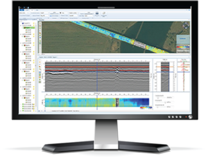
High resolution radar surveys result in large amounts of data, which can make them difficult to process, navigate and analyze. 3D-Radar has met this challenge by developing 3D-Radar Examiner. This unique package uses the very latest in software techniques and tools to fully utilize the speed of modern PCs. Examiner is able to process radar data orders of magnitude faster than it can be collected.
Both Overview and Explore modes displayed with map satellite imagery and layers traced.
Once processed, 3D-Radar Examiner offers a unique live geo-referenced view of the data, overlaid on maps or aerial photos. This view provides a bird’s eye view of all the complete data set, and allows the user to pan, zoom and dive in real time. The same view offers edit functions, annotation of features, manual correction of position errors, etc. All updates happen automatically: Change depth, change the GPS data, or change the color map, and the geo-referenced data updates on screen instantly. The state of the art GPS filtering ensures good position accuracy, but tracks can be edited manually as well.
Once a point of interest has been identified, you can drill down to it by double clicking on the position to center on it in the more traditional Region Explorer view, which provides three volume slices. You can also annotate points of interest and export to AutoCad, GIS or Google Earth. Other export options include imagery, geo-referenced images in virtually any map projection, video, point clouds, numerical data, radar data export, etc.
Supports multiple swaths / multiple profiles datasets with geo-referenced data
Fully documented Software Development Kit for customizing tools and visualization
Optimized multicore usage dramatically slashes processing time
Designed to handle huge data sets
Wide selection of processing options for filtering, background removal and 3-d migration
Intuitive GUI optimized to navigate quickly in large geo referenced data sets
Improved positioning accuracy with correlation-based correction of errors and outliers
Easy to use annotation function
Semi-automatic tracing of interfaces in 3 dimensions
Support for import and export of maps and geo-referenced images
Export of video, CAD (DWG/DXF), GIS (GeoJSON), Google Earth (KMZ) and point clouds.
High Speed 3D GPR Achieves both High Resolution and Deep Penetration
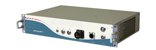
GeoScope™ MkIV
The 3D-Radar GeoScope™ MkIV Ground Penetrating Radar (GPR) raises the standard for high speed, high-density three-dimensional sub-surface imaging. The MkIV is the fourth generation 3D-Radar GeoScope™ and further exploits the application of step-frequency technology to Ground Penetrating Radar. The GeoScope™ MkIV enables high-density high speed 3D data capture with unique combination of deep subsurface penetration coupled to high resolution.
Optimum resolution at all depths: Step-frequency technology enables the users to achieve the best possible resolution at each investigation depth. Penetration and the highest resolution are simultaneously achieved with only ONE single antenna array. No need to employ different frequency antennas to adapt to different depths.
Unprecedented area survey speed (work rate): Very high scan rates and an efficient sampling method enables the GeoScope Mk IV to provide full resolution 3D imagery with a 2.4 m antenna array at highway speeds.
High resolution full 3D sub surface imagery: 7.5 cm channel spacing in the antenna array combined with 3GHz bandwidth ensures high-density sampling as required by utility mapping, military applications and archaeology prospecting.
Wide range of antenna arrays with uniform response across the elements:The Mk IV is compatible with all DX- and DXG-series antenna arrays ranging up to 330 cm in width.
DX & DXG Series Antennas
Flexible Array Options
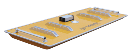
3D-Radar manufactures a wide range of antenna arrays suitable for different applications and operational requirements. Our current selection of arrays range from 8 to 41 survey channels. Available in ground-coupled or air-launched configurations, the width of the antenna arrays ranges between 90 cm to 3.3 meters with frequency ranges from 200 MHz – 3 GHz.
DX-Series Air-launched Antenna Arrays
3D-Radar DX-Series antenna arrays allow scanning of up to 41 channels of GPR data over a continuous 200MHz to 3GHz frequency range. Near surface signal fidelity with the DX antenna is enhanced by orienting the transmitting and receiving antenna elements in opposite directions, minimizing antenna ringing while delivering high resolution imagery.
The air-coupled antenna design offers clear impulse response with low ringing and high suppression of the direct wave from transmitter to receiver. Operated with the GeoScope ™ Mk IV step-frequency radar, the DX-Series antennas offer a unique capability of collecting 3-dimensional GPR data with dense line spacing, allowing full 3-dimensional data processing. The antenna has support for multi-offset recording, and has a built in GPS receiver.
Ideal for applications such as high speed road/bridge deck inspection, network level utility mapping, railway ballast inspection and military uses, the DX Series of antennas are available in 0.9, 1.8, 2.1, 2.4 and 3.3 meter widths. Other antenna sizes are possible. Contact 3d-Radar if your application requires a custom size.
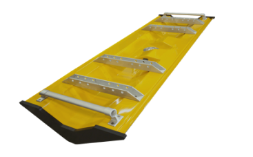
DXG-Series Ground-coupled Antenna Arrays
The DXG-Series of antennas are idealy suited to applications such as bridge deck inspection, utility mapping UXO remediation, archaeology or any application where high resolution GPR data needs to be acquired at all possible depths. Compatible with the GeoScope ™ Mk IV ultra-wideband step frequency GPR, the DXG antenna is available in 90cm, 1.2m and 1.8m widths, with other sizes available on a custom order basis. Designed to be compatible with the DX series of antennas, the DXG brings the advantages of a ground coupled solution into the 3d realm for the first time.
Why settle for 2 dimensions? - Kontur