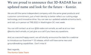
3D-RADAR PROUDLY ANNOUNCES
EXAMINER release 3.4 – Full volume stitching !
Data collected in multiple passes can be combined (“stitched”) into
one single 3-dimensional data set.
Image courtesy CalTrans
3D GROUND PENETRATING RADAR
NEXT GENERATION
Railroads
Archaeology
Airport runways
Bridge decks
Pavement delamination
Utility mapping
NON-DESTRUCTIVE TESTING
Virtual trenching and 3D interface tracing
Fully geo-referenced visualization environment
Results immediately available for field analysis
Optimized for large 3D GPR datasets
FIELD-PROVEN SOFTWARE
MULTIPLE MOUNTING OPTIONS
Only 5 major components
One GeoScope™ works with any 3D-Radar antenna
Deeper penetration, high resolution at all depths
Offer highway speed collection and excellent surface & near surface resolution
At the National Center for Asphalt Technology and approved as an NDT technology for the US Federal Highway SHRP2 RD-06 program.
Paul Collins
GPR Manager, CAT Surveys, LTD.
“3D-Radar technology allows us to collect comprehensive, user defined data sets, that are tailored to the project needs. We can produce multiple evaluations from one application. Software, hardware and positioning all seamlessly combine for great results, which benefits my team and our clients.”